
Most Scenic Drives In The USA
Pacific Coast Highway (California):
The Pacific Coast Highway, also known as California State Route 1, is a scenic road trip that winds along the stunning coastline of California. This iconic highway offers breathtaking views of the Pacific Ocean, rugged cliffs, charming coastal towns, and beautiful beaches. Get ready for a memorable journey filled with natural beauty and unforgettable experiences.
Total Distance: The Pacific Coast Highway stretches for approximately 656 miles (1,056 kilometers), from Dana Point in Southern California to Leggett in Northern California.
Starting and Ending Point: The trip can be started from either end, but for this guide, we’ll start from the southern end in Dana Point and end at the northern point in Leggett.
Must-See Attractions:
- Big Sur: Known for its dramatic coastline and picturesque views, Big Sur is a must-see destination along the Pacific Coast Highway. Don’t miss McWay Falls and Bixby Bridge.
- Hearst Castle: Located near San Simeon, Hearst Castle is a magnificent mansion that offers guided tours, giving you a glimpse into the extravagant lifestyle of media magnate William Randolph Hearst.
- Monterey Bay Aquarium: Situated in Monterey, this renowned aquarium showcases a diverse range of marine life, including sea otters, penguins, and sharks.
- Santa Barbara: Known as the “American Riviera,” Santa Barbara offers beautiful beaches, Spanish architecture, and a vibrant downtown area with excellent shopping and dining options.
- Golden Gate Bridge: As you approach San Francisco, you’ll have the chance to cross the iconic Golden Gate Bridge. Stop at the vista points for breathtaking views of the city skyline.
Best Time to Visit: The Pacific Coast Highway can be enjoyed throughout the year, but the ideal time to visit is during the spring and fall seasons. These months offer pleasant weather, fewer crowds, and clear skies for better visibility of the coastal scenery.
Duration of the Trip: To fully experience the Pacific Coast Highway, it is recommended to allocate at least five to seven days for the journey. This allows for ample time to explore the attractions, enjoy leisurely drives, and indulge in the coastal charm of the towns along the way.
Note: Remember to check for road closures or any travel advisories before embarking on your trip, as conditions may vary.
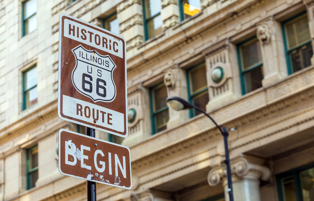
Route 66 (Illinois to California):
Route 66, also known as the “Main Street of America,” is a legendary road trip that spans from Illinois to California. This historic highway captures the essence of American road travel, taking you through small towns, iconic landmarks, and diverse landscapes. Prepare to step back in time and experience the nostalgia of Route 66.
Total Distance: Route 66 covers approximately 2,448 miles (3,940 kilometers) from Chicago, Illinois, to Santa Monica, California.
Starting and Ending Point: The journey typically begins in Chicago, Illinois, at Grant Park and ends at the Santa Monica Pier in Santa Monica, California.
Must-See Attractions:
- Cadillac Ranch (Amarillo, Texas): This unique art installation features a row of buried Cadillac cars, creating a visually striking sight that has become an iconic symbol of Route 66.
- Petrified Forest National Park (Arizona): Explore the ancient forests and vibrant petrified wood formations in this national park, where you can witness the remnants of prehistoric trees turned to stone.
- Grand Canyon National Park (Arizona): Although not directly on Route 66, a slight detour will lead you to one of the world’s most awe-inspiring natural wonders, offering breathtaking views and numerous hiking opportunities.
- Santa Fe (New Mexico): Immerse yourself in the rich culture and history of Santa Fe, known for its adobe architecture, art galleries, and vibrant culinary scene.
- California Route 66 Museum (Victorville, California): Learn about the history and significance of Route 66 at this engaging museum, which showcases artifacts, photographs, and exhibits dedicated to the road’s legacy.
Best Time to Visit: The best time to travel Route 66 is during the spring and fall seasons when the weather is mild and pleasant. Summers can be hot in some areas, and winter months may bring snow and icy conditions in certain regions.
Duration of the Trip: To fully appreciate the sights and attractions along Route 66, it is recommended to allocate at least two weeks for the journey. This allows for a leisurely pace, giving you time to explore the unique towns, landmarks, and roadside attractions that make this road trip truly special.
Note: While some sections of Route 66 are well-preserved and still driveable, others have been replaced by modern highways. It’s advisable to consult a Route 66 guidebook or online resources to plan your route and ensure you experience the authentic segments of the road.
Blue Ridge Parkway (North Carolina and Virginia):
The Blue Ridge Parkway is a scenic road trip that winds through the stunning Appalachian Mountains, offering breathtaking views of rolling hills, vibrant forests, and charming landscapes. Stretching from North Carolina to Virginia, this iconic parkway is renowned for its natural beauty, outdoor recreational opportunities, and cultural heritage.
Total Distance: The Blue Ridge Parkway covers a distance of approximately 469 miles (755 kilometers), starting at the Great Smoky Mountains National Park in North Carolina and ending at Shenandoah National Park in Virginia.
Starting and Ending Point: The trip can be started from either end, but for this guide, we’ll start from the southern end at Great Smoky Mountains National Park and end at Shenandoah National Park in Virginia.
Must-See Attractions:
- Grandfather Mountain (North Carolina): Visit this iconic peak with its famous Mile High Swinging Bridge and enjoy breathtaking views of the surrounding mountains.
- Linville Gorge and Linville Falls (North Carolina): Explore the deep Linville Gorge and witness the impressive waterfalls cascading down the rugged cliffs.
- Blue Ridge Music Center (Virginia): Immerse yourself in the rich musical heritage of the region through live performances and interactive exhibits showcasing traditional Appalachian music.
- Peaks of Otter (Virginia): Hike the picturesque trails around the Peaks of Otter and enjoy stunning vistas of the surrounding mountains and serene Abbott Lake.
- Mabry Mill (Virginia): Discover this beautifully preserved historic mill, where you can learn about traditional Appalachian culture and witness demonstrations of milling and woodworking.
Best Time to Visit: The Blue Ridge Parkway is a year-round destination, each season offering its own unique charm. However, the best time to visit is during the fall (September to November) when the foliage transforms into a kaleidoscope of vibrant colors. Spring (April to June) also showcases blooming wildflowers, while summer (June to August) provides pleasant weather for outdoor activities.
Duration of the Trip: To fully appreciate the scenic beauty and attractions along the Blue Ridge Parkway, it is recommended to allocate at least five to seven days for the journey. This allows for a relaxed pace, allowing you to explore the numerous overlooks, hike the trails, and savor the tranquil beauty of the Appalachian Mountains.
Note: Some portions of the Blue Ridge Parkway may be closed during winter due to snow and ice. It’s advisable to check for road closures and current conditions before embarking on your trip.
Overseas Highway (Florida Keys):
The Overseas Highway, also known as U.S. Route 1, is an iconic road trip that takes you through the stunning Florida Keys. This scenic highway stretches over a series of bridges and offers breathtaking views of turquoise waters, sandy beaches, and a laid-back tropical atmosphere. Get ready to embark on a journey filled with sunshine, relaxation, and the vibrant culture of the Florida Keys.
Total Distance: The Overseas Highway covers a distance of approximately 113 miles (182 kilometers), starting in Key Largo and ending in Key West.
Starting and Ending Point: The trip begins in Key Largo, located in the uppermost part of the Florida Keys, and ends in Key West, the southernmost point of the continental United States.
Must-See Attractions:
- John Pennekamp Coral Reef State Park (Key Largo): Dive into the underwater paradise of the only living coral reef in the continental United States, offering opportunities for snorkeling, scuba diving, and boat tours.
- Bahia Honda State Park (Big Pine Key): Relax on the picturesque beaches of Bahia Honda State Park, known for its clear waters, sandy shores, and abundant marine life.
- Seven Mile Bridge (Marathon): Cross this iconic bridge that spans seven miles, offering stunning views of the turquoise waters and neighboring islands.
- Islamorada: Visit this charming village known for its excellent fishing opportunities, vibrant art galleries, and delicious seafood restaurants.
- Key West: Explore the lively and colorful streets of Key West, known for its vibrant nightlife, historic sites like the Ernest Hemingway Home, and the famous Mallory Square sunset celebration.
Best Time to Visit: The Florida Keys can be enjoyed year-round, but the best time to visit is during the dry season, which spans from November to April. This period offers pleasant temperatures, lower humidity, and a reduced chance of rainfall. Keep in mind that the Keys can be busy during holidays and winter months, so planning and booking accommodations in advance is recommended.
Duration of the Trip: To fully immerse yourself in the beauty and charm of the Florida Keys, it is recommended to allocate at least three to five days for the journey. This allows for ample time to explore the attractions, enjoy water activities, and soak up the relaxed island atmosphere.
Note: Keep an eye on the weather conditions and hurricane alerts, especially during the Atlantic hurricane season, which runs from June to November.
Great River Road (Mississippi River):
The Great River Road is a scenic road trip that follows the course of the mighty Mississippi River, allowing you to explore the rich history, culture, and natural beauty of the regions it passes through. This iconic highway spans multiple states and offers picturesque river views, charming river towns, and a glimpse into the heartland of America.
Total Distance: The Great River Road covers a distance of approximately 2,340 miles (3,766 kilometers), stretching from Minnesota to Louisiana.
Starting and Ending Point: The trip can be started from either end, but for this guide, we’ll start from the northern end at Itasca State Park in Minnesota and end at Venice in Louisiana.
Must-See Attractions:
- Itasca State Park (Minnesota): Begin your journey at the headwaters of the Mississippi River, where you can walk across the river and explore the pristine forests and lakes of the park.
- Gateway Arch (St. Louis, Missouri): Visit this iconic monument that symbolizes the westward expansion of the United States, offering stunning views of the city and the Mississippi River.
- Natchez (Mississippi): Explore this historic town known for its well-preserved antebellum mansions, charming streets, and beautiful views of the river.
- Vicksburg National Military Park (Mississippi): Learn about the Civil War history and visit the well-preserved battlefield and historic sites in this important location.
- New Orleans (Louisiana): End your journey in the vibrant city of New Orleans, known for its unique blend of cultures, lively music scene, and delicious cuisine.
Best Time to Visit: The Great River Road can be enjoyed year-round, but the best time to visit is during the spring and fall seasons when the weather is mild and pleasant. Spring brings blooming flowers and vibrant foliage, while fall showcases the stunning colors of the changing leaves. Summers can be hot and humid, while winters may bring colder temperatures.
Duration of the Trip: To fully experience the diverse attractions and immerse yourself in the history and beauty of the Great River Road, it is recommended to allocate at least two weeks for the journey. This allows for a leisurely pace, giving you time to explore the river towns, visit museums, and take in the scenic views along the way.
Note: The Great River Road passes through multiple states, and road conditions and attractions may vary. It’s advisable to plan your route in advance and check for any road closures or construction updates.
Going-to-the-Sun Road (Montana):
Going-to-the-Sun Road is a breathtaking scenic drive that cuts through the heart of Glacier National Park in Montana. This iconic road trip offers stunning alpine landscapes, pristine lakes, cascading waterfalls, and an abundance of wildlife. Prepare for an unforgettable adventure as you traverse this engineering marvel and immerse yourself in the natural wonders of Glacier National Park.
Total Distance: Going-to-the-Sun Road covers a distance of approximately 50 miles (80 kilometers) as it winds through Glacier National Park.
Starting and Ending Point: The journey begins at the West Glacier entrance of Glacier National Park and ends at the St. Mary entrance on the eastern side.
Must-See Attractions:
- Logan Pass: Located at the highest point along the road, Logan Pass offers awe-inspiring views of the surrounding mountains and is a prime spot for wildlife sightings, including bighorn sheep and mountain goats. Don’t miss the visitor center and the opportunity to explore the trails.
- Hidden Lake: Take a short hike from Logan Pass to Hidden Lake, a pristine alpine lake surrounded by rugged peaks and wildflowers. The trail offers stunning vistas and the chance to spot wildlife.
- Avalanche Creek: Stop at Avalanche Creek for a refreshing break and explore the Trail of the Cedars, a wheelchair-accessible boardwalk that meanders through an ancient forest filled with towering cedar trees.
- Lake McDonald: Visit the largest lake in Glacier National Park, known for its crystal-clear waters and scenic views. Enjoy a boat tour, go kayaking, or simply relax on the shore and take in the beauty of the lake.
- Many Glacier: Venture off the main road to visit Many Glacier, a picturesque area known for its stunning mountain scenery, glacier-carved valleys, and opportunities for hiking, wildlife watching, and boat tours on Swiftcurrent Lake.
Best Time to Visit: The best time to experience Going-to-the-Sun Road is during the summer months, typically from late June to September when the road is fully open and accessible. This period offers pleasant weather and allows you to enjoy the full range of activities and attractions in Glacier National Park. However, be prepared for potential crowds, especially in July and August.
Duration of the Trip: To fully appreciate the beauty and attractions along Going-to-the-Sun Road, it is recommended to allocate at least one full day. This will allow you to drive the road at a leisurely pace, make stops at the various viewpoints and attractions, and embark on short hikes to explore the natural wonders of Glacier National Park.
Note: Due to the high elevation and mountainous terrain, weather conditions can change rapidly, even during the summer months. It’s important to check for any road closures, weather advisories, and park regulations before embarking on your trip.
The Loneliest Road (Nevada):
The Loneliest Road, also known as U.S. Route 50, is a captivating road trip that stretches across the vast and desolate landscapes of Nevada. This highway earned its nickname due to its remote and sparsely populated surroundings, offering a unique and serene journey through the heart of the American West. Get ready for a road trip filled with solitude, natural wonders, and the opportunity to truly disconnect from the hustle and bustle of everyday life.
Total Distance: The Loneliest Road spans approximately 287 miles (462 kilometers) across Nevada, starting at the Utah-Nevada border and ending at the Nevada-California border.
Starting and Ending Point: The journey begins at the Utah-Nevada border, near the town of Baker, and ends at the Nevada-California border, close to the town of Carson City.
Must-See Attractions:
- Great Basin National Park: Venture off the Loneliest Road to explore the stunning landscapes of Great Basin National Park. Marvel at the ancient bristlecone pine trees, tour the Lehman Caves, and hike to alpine lakes and scenic viewpoints.
- Hickison Petroglyph Recreation Area: Discover an impressive collection of Native American petroglyphs etched into volcanic rock formations. Take a leisurely hike along the trails and immerse yourself in the rich cultural history of the area.
- Sand Mountain Recreation Area: Witness the towering sand dunes of Sand Mountain, a popular spot for sandboarding, off-roading, and enjoying the unique desert scenery.
- Spencer Hot Springs: Take a relaxing break at Spencer Hot Springs, where you can soak in natural hot pools surrounded by the vast desert landscape. It’s a perfect spot to rejuvenate and unwind.
- Nevada State Capitol Complex (Carson City): As you approach the end of the Loneliest Road, explore the Nevada State Capitol Complex in Carson City. Visit the Nevada State Museum, stroll through historic streets, and learn about the rich history of the state.
Best Time to Visit: The Loneliest Road can be traveled year-round, but the best time to visit is during the spring and fall seasons when the weather is milder. Summers can be hot in Nevada, so it’s advisable to carry plenty of water and take precautions for the desert heat. Winters may bring cold temperatures and occasional snowfall, so check for weather conditions and road closures during the winter months.
Duration of the Trip: To fully embrace the solitude and immerse yourself in the unique landscapes along the Loneliest Road, it is recommended to allocate at least two to three days for the journey. This allows for a leisurely pace, giving you time to explore the attractions, enjoy scenic viewpoints, and truly appreciate the remote beauty of Nevada’s desert landscapes.
Note: Due to the remote nature of the Loneliest Road, it’s important to plan ahead and ensure you have sufficient fuel, water, and supplies before embarking on your journey. Services and facilities may be limited along the route, so be prepared for self-sufficiency.
Best Road Trips in America
Highway 1 to Key West (Florida):
Highway 1 to Key West is a scenic road trip that takes you through the beautiful Florida Keys, offering a captivating journey filled with stunning ocean views, picturesque islands, and a laid-back tropical ambiance. This iconic highway is renowned for its breathtaking bridges, vibrant coral reefs, and the vibrant culture of the Florida Keys. Get ready to embark on a memorable adventure as you make your way to the southernmost point of the continental United States.
Total Distance: Highway 1 to Key West covers a distance of approximately 113 miles (182 kilometers), starting in Florida City and ending in Key West.
Starting and Ending Point: The trip begins in Florida City, located south of Miami, and ends in Key West, the southernmost point of the Florida Keys.
Must-See Attractions:
- Key Largo: Explore the underwater wonders of Key Largo, known for its excellent snorkeling and diving opportunities. Visit John Pennekamp Coral Reef State Park and encounter colorful coral formations and abundant marine life.
- Islamorada: Discover the “Village of Islands,” where you can enjoy world-class fishing, visit the Theater of the Sea marine park, and savor fresh seafood at waterfront restaurants.
- Marathon: Stop by Marathon and visit the Turtle Hospital, where you can learn about the conservation efforts for sea turtles. Relax on the beautiful beaches or explore the scenic nature trails.
- Seven Mile Bridge: Drive across the iconic Seven Mile Bridge, offering breathtaking views of the turquoise waters and surrounding islands. Don’t forget to snap some photos at the scenic overlooks.
- Key West: Immerse yourself in the lively and eclectic atmosphere of Key West. Explore the historic Old Town, visit the Ernest Hemingway Home and Museum, enjoy the vibrant nightlife on Duval Street, and watch the famous Key West sunset at Mallory Square.
Best Time to Visit: The best time to visit Highway 1 to Key West is during the dry season, which typically runs from November to April. This period offers pleasant temperatures, lower humidity, and a reduced chance of rainfall. It’s advisable to avoid the peak hurricane season, which is from June to November, as the Florida Keys can be affected by tropical storms or hurricanes.
Duration of the Trip: To fully enjoy the attractions and experience the relaxed island vibe along Highway 1 to Key West, it is recommended to allocate at least three to five days for the journey. This allows for a leisurely pace, giving you time to explore the different keys, enjoy water activities, and soak up the unique atmosphere of each island.
Note: The Florida Keys can be popular tourist destinations, especially during the winter months. It’s advisable to book accommodations in advance and be prepared for potential crowds, especially in Key West.
Highway 101 (Oregon and Washington):
Introduction: Highway 101, also known as the Pacific Coast Highway, is an iconic road trip route that stretches along the scenic coastlines of Oregon and Washington. This breathtaking journey offers a blend of stunning ocean views, charming coastal towns, majestic forests, and unique natural attractions. Get ready to experience the beauty of the Pacific Northwest as you embark on an unforgettable adventure along Highway 101.
Total Distance: Highway 101 spans approximately 1,500 miles (2,414 kilometers) as it winds its way through the coastal regions of Oregon and Washington.
Starting and Ending Point: The trip can be started from either end, but for this guide, we’ll start from the southern end at the Oregon-California border and end at the northern end at the Washington-Oregon border.
Must-See Attractions:
- Cannon Beach (Oregon): Visit the iconic Haystack Rock and explore the beautiful sandy beach. Take a stroll through the charming town and admire the coastal scenery.
- Cape Perpetua Scenic Area (Oregon): Marvel at the rugged cliffs, dramatic ocean vistas, and lush forests in this scenic area. Don’t miss the captivating view from the top of Cape Perpetua Overlook.
- Heceta Head Lighthouse (Oregon): Discover the historic lighthouse and enjoy panoramic views of the coastline from the viewpoint. Take a guided tour to learn about its fascinating history.
- Olympic National Park (Washington): Venture off Highway 101 to explore the diverse landscapes of Olympic National Park. Hike through lush rainforests, discover serene lakes, and marvel at the rugged peaks of the Olympic Mountains.
- Ruby Beach (Washington): Experience the wild and untamed beauty of Ruby Beach with its sea stacks, driftwood, and captivating sunsets. Take a leisurely stroll along the shore and immerse yourself in the coastal serenity.
Best Time to Visit: The best time to travel along Highway 101 is during the summer months, from June to September. This period offers the most pleasant weather with mild temperatures and less rainfall. However, keep in mind that the coastal areas can be foggy at times. If you prefer fewer crowds, consider visiting during the shoulder seasons of spring or fall.
Duration of the Trip: To fully enjoy the attractions, scenic viewpoints, and natural wonders along Highway 101, it is recommended to allocate at least one to two weeks for the journey. This allows for a leisurely pace, giving you time to explore the coastal towns, visit national parks, and embark on scenic hikes along the way.
Note: While traveling on Highway 101, be aware of potential road closures or detours, especially during winter months when storms can cause disruptions. Plan your route in advance and check for any updates or advisories.
Million Dollar Highway (Colorado):
The Million Dollar Highway is a legendary road trip route that winds through the breathtaking landscapes of the San Juan Mountains in Colorado. This thrilling and scenic drive offers dramatic mountain vistas, steep cliffs, cascading waterfalls, and charming mountain towns. Prepare for an exhilarating adventure as you navigate the twists and turns of this iconic highway and immerse yourself in the rugged beauty of Colorado.
Total Distance: The Million Dollar Highway refers to a 25-mile (40-kilometer) stretch of U.S. Route 550 between the towns of Ouray and Silverton in Colorado. However, the entire road trip from Durango to Ouray covers approximately 70 miles (113 kilometers).
Starting and Ending Point: For this guide, we’ll start the journey from the town of Durango and end in the picturesque town of Ouray.
Must-See Attractions:
- Durango: Begin your journey in Durango, a historic town known for its Wild West charm. Explore the lively downtown area, visit the Durango & Silverton Narrow Gauge Railroad, and enjoy outdoor activities like hiking and mountain biking.
- Silverton: Arrive in Silverton, a small mountain town with a rich mining history. Stroll along its historic streets, visit the Mining Heritage Center, and take in the panoramic views of the surrounding peaks.
- Million Dollar Highway: Experience the thrill of driving along the Million Dollar Highway. Enjoy the sweeping views of the San Juan Mountains, navigate hairpin turns, and marvel at the rugged beauty of the cliffs and canyons.
- Ouray: Reach the town of Ouray, known as the “Switzerland of America” for its stunning mountain scenery. Soak in the natural hot springs, hike to Box Canyon Falls, and explore the charming shops and restaurants along Main Street.
Best Time to Visit: The best time to travel the Million Dollar Highway is during the summer months, from June to September. This period offers the most favorable weather conditions with clear roads and mild temperatures. However, be prepared for occasional afternoon thunderstorms, and note that snow can persist on the highest passes even in early summer. Fall is also a beautiful time to visit, as the mountains are adorned with vibrant autumn colors.
Duration of the Trip: To fully appreciate the scenic beauty and explore the attractions along the Million Dollar Highway, it is recommended to allocate at least two to three days for the journey. This allows for a leisurely pace, giving you time to stop at viewpoints, take short hikes, and soak in the charm of the mountain towns.
Note: The Million Dollar Highway is known for its steep cliffs and hairpin turns. Drive cautiously and be mindful of other vehicles, as the road can be narrow in certain sections. Check for any road closures or construction updates before embarking on your trip.
Beartooth Highway (Montana and Wyoming):
The Beartooth Highway is a breathtaking road trip route that traverses the majestic landscapes of Montana and Wyoming. This scenic drive offers awe-inspiring views of snow-capped mountains, alpine lakes, and vast meadows. Known for its high elevation and stunning natural beauty, the Beartooth Highway takes you through the heart of the Beartooth Mountains and the Absaroka-Beartooth Wilderness. Prepare for an unforgettable adventure as you embark on this epic journey through the rugged wilderness of the Northern Rockies.
Total Distance: The Beartooth Highway spans approximately 68 miles (109 kilometers) from Red Lodge, Montana, to the northeast entrance of Yellowstone National Park in Wyoming.
Starting and Ending Point: The trip begins in the town of Red Lodge, Montana, and ends at the northeast entrance of Yellowstone National Park in Wyoming.
Must-See Attractions:
- Beartooth Pass: Ascend to the highest point on the Beartooth Highway at Beartooth Pass, located at an elevation of 10,947 feet (3,337 meters). Take in the panoramic views of the surrounding mountains and alpine landscapes.
- Rock Creek Vista Point: Stop at Rock Creek Vista Point for breathtaking views of the canyon below. Admire the jagged cliffs, deep valleys, and the winding path of Rock Creek.
- Beartooth Lake: Take a detour to Beartooth Lake and enjoy the serene beauty of this alpine lake. You can fish, picnic, or simply relax amidst the picturesque surroundings.
- Top of the World Store: Visit the Top of the World Store, situated near the Wyoming border, for a chance to refuel, grab a bite to eat, and experience the unique atmosphere of this remote mountain store.
- Northeast Entrance of Yellowstone National Park: As you reach the end of the Beartooth Highway, take the opportunity to explore the wonders of Yellowstone National Park. Witness geothermal features, marvel at the famous Yellowstone River, and keep an eye out for wildlife.
Best Time to Visit: The Beartooth Highway is typically open from late May to mid-October, depending on weather conditions. The best time to travel the highway is during the summer months, from June to September, when the road is fully accessible and the weather is pleasant. However, be prepared for cooler temperatures at higher elevations, and always check for any road closures or travel advisories before your trip.
Duration of the Trip: To fully savor the scenic beauty and make the most of the attractions along the Beartooth Highway, it is recommended to allocate at least one to two days for the journey. This allows for a leisurely pace, giving you time to stop at viewpoints, take short hikes, and immerse yourself in the pristine wilderness of the region.
Note: The Beartooth Highway reaches high elevations and includes steep grades and hairpin turns. Drive with caution, especially during inclement weather or when there is snow on the road. Make sure your vehicle is well-maintained and adequately prepared for the mountainous terrain.
Columbia River Highway (Oregon):
The Columbia River Highway is a picturesque road trip route that winds along the breathtaking Columbia River Gorge in Oregon. This scenic drive offers stunning views of towering cliffs, cascading waterfalls, lush forests, and the mighty Columbia River itself. Known for its natural beauty and unique geological formations, the Columbia River Highway is a perfect blend of outdoor adventures and scenic wonders. Get ready to embark on an unforgettable journey through one of Oregon’s most iconic landscapes.
Total Distance: The Columbia River Highway covers approximately 75 miles (121 kilometers) from Troutdale to The Dalles in Oregon.
Starting and Ending Point: The trip starts in Troutdale, a town located just east of Portland, and ends in The Dalles, situated further east along the Columbia River.
Must-See Attractions:
- Multnomah Falls: Begin your journey with a visit to Multnomah Falls, one of the most famous waterfalls in Oregon. Marvel at the impressive 620-foot (189-meter) cascade and take a short hike to the upper viewpoint for a panoramic view.
- Crown Point Vista House: Stop at Crown Point Vista House, a historic observatory perched on a cliff. Enjoy sweeping views of the Columbia River Gorge and learn about the area’s history and geology.
- Horsetail Falls: Admire the beauty of Horsetail Falls, a stunning waterfall that plunges 176 feet (54 meters) into a sparkling pool. Take a short hike to get closer and feel the mist on your face.
- Hood River: Explore the vibrant town of Hood River, known for its outdoor recreational opportunities and charming downtown area. Enjoy windsurfing, kiteboarding, or simply take a stroll along the waterfront.
- The Dalles: Reach The Dalles, a historic city situated at the eastern end of the Columbia River Gorge. Visit the Columbia Gorge Discovery Center to learn about the area’s natural and cultural history, and explore the nearby Dalles Dam.
Best Time to Visit: The best time to travel the Columbia River Highway is during the spring and fall seasons. Spring brings vibrant wildflowers, lush greenery, and the highest flow of waterfalls. Fall offers beautiful foliage colors and fewer crowds. Summer can be busy, especially on weekends, so consider visiting on weekdays or early in the morning to avoid crowds. Be aware that winter can bring icy conditions and potential closures in certain sections, so check for road conditions before your trip.
Duration of the Trip: To fully appreciate the attractions and natural wonders along the Columbia River Highway, it is recommended to allocate at least one to two days for the journey. This allows for a leisurely pace, giving you time to stop at viewpoints, hike to waterfalls, and explore the towns along the way.
Note: Some sections of the original Columbia River Highway have been replaced by Interstate 84. However, there are scenic alternative routes and access points to the historic highway, allowing you to experience its beauty.
Route 1 – Big Sur (California):
Route 1, also known as the Pacific Coast Highway, offers one of the most spectacular road trip experiences in the world as it winds along the dramatic cliffs of the Big Sur coastline in California. This iconic drive combines breathtaking ocean views, rugged landscapes, and picturesque coastal towns. Get ready to embark on a journey of discovery as you explore the natural wonders, hidden beaches, and charming communities along Route 1 in Big Sur.
Total Distance: The Big Sur section of Route 1 spans approximately 90 miles (145 kilometers) from Carmel in the north to San Simeon in the south.
Starting and Ending Point: The trip can be started from either end, but for this guide, we’ll start from Carmel, a town located on the Monterey Peninsula, and end at San Simeon, home to the famous Hearst Castle.
Must-See Attractions:
- Bixby Creek Bridge: Marvel at the iconic Bixby Creek Bridge, one of the most photographed spots along the Pacific Coast Highway. Enjoy panoramic views of the bridge and the surrounding coastline.
- Pfeiffer Big Sur State Park: Immerse yourself in the beauty of Pfeiffer Big Sur State Park. Take a hike through the redwood groves, relax by the Big Sur River, and visit the picturesque Pfeiffer Beach.
- McWay Falls: Witness the stunning McWay Falls, a waterfall that drops from a cliff into the turquoise waters of McWay Cove. Take in the breathtaking view from the overlook along the highway.
- Point Sur State Historic Park: Explore Point Sur State Historic Park and visit the historic Point Sur Lighthouse, perched on a volcanic rock outcrop. Take a guided tour to learn about its fascinating history.
- Elephant Seal Rookery: Stop by the Elephant Seal Rookery near San Simeon to observe these magnificent marine mammals in their natural habitat. Watch them lounge on the beach and listen to their distinctive calls.
Best Time to Visit: The Big Sur section of Route 1 is beautiful year-round, but the best time to visit is during the spring and fall seasons. These seasons offer milder temperatures, fewer crowds, and clear skies. Spring brings blooming wildflowers, while fall offers the chance to see migrating whales along the coast. Summer can be busy, especially on weekends, and winter may bring rainstorms and potential road closures. Plan your trip accordingly and check for any road advisories before you go.
Duration of the Trip: To fully experience the beauty and attractions of Big Sur along Route 1, it is recommended to allocate at least two to three days for the journey. This allows for a relaxed pace, giving you time to stop at viewpoints, explore the state parks, and soak in the coastal ambiance.
Note: The Big Sur section of Route 1 is known for its winding roads and steep cliffs. Drive with caution, follow posted speed limits, and be prepared for narrow stretches of the highway. Take your time to enjoy the scenery and make frequent stops at designated pullouts.
Route 12 – Scenic Byway (Utah):
Route 12, also known as the Scenic Byway, is an extraordinary road trip route that takes you through the diverse and breathtaking landscapes of Utah. This scenic drive offers a remarkable blend of natural wonders, including red rock canyons, towering cliffs, lush forests, and pristine alpine meadows. From start to finish, Route 12 promises awe-inspiring vistas, outdoor adventures, and encounters with Utah’s rich history and culture. Get ready to embark on a remarkable journey through the heart of Utah’s stunning scenery.
Total Distance: Route 12 covers approximately 123 miles (198 kilometers) from Panguitch to Torrey in Utah.
Starting and Ending Point: For this guide, we’ll start the journey from Panguitch, a charming town situated in southern Utah, and end in Torrey, a gateway to Capitol Reef National Park.
Must-See Attractions:
- Red Canyon: Begin your adventure with a visit to Red Canyon, also known as the “Little Bryce Canyon.” Explore the vibrant red rock formations, hike the trails, and marvel at the unique geological features.
- Bryce Canyon National Park: Discover the otherworldly beauty of Bryce Canyon National Park. Admire the famous hoodoos, hike through the scenic trails, and witness the stunning colors of the amphitheaters at sunrise or sunset.
- Grand Staircase-Escalante National Monument: Immerse yourself in the rugged wilderness of the Grand Staircase-Escalante National Monument. Explore the slot canyons, hike to scenic viewpoints, and encounter the rich geological and paleontological treasures of the area.
- Kodachrome Basin State Park: Visit Kodachrome Basin State Park and be enchanted by the unique rock spires, colorful sandstone formations, and hiking trails that weave through this picturesque desert landscape.
- Capitol Reef National Park: Reach the end of Route 12 in Torrey, the gateway to Capitol Reef National Park. Marvel at the towering cliffs, explore the scenic drives and trails, and learn about the history of the Fremont Native American culture.
Best Time to Visit: The best time to travel Route 12 is during the spring and fall seasons when the weather is mild, and the landscapes are vibrant. Spring brings blooming wildflowers, while fall offers stunning foliage colors. Summer can be hot, especially in the lower elevations, and winter may bring snow and potential road closures in certain sections. Plan your trip accordingly and check for any road or weather advisories before you go.
Duration of the Trip: To fully experience the beauty and attractions along Route 12, it is recommended to allocate at least three to four days for the journey. This allows for a relaxed pace, giving you time to explore the national parks, hike the trails, and soak in the natural wonders along the way.
Note: Some sections of Route 12 pass through remote and rugged areas, with limited services and cell phone coverage. Plan ahead, carry ample water and supplies, and be prepared for changing weather conditions. Additionally, some areas may require permits or fees, so check ahead of time for any necessary arrangements.
Route 89 (Arizona, Utah, and Wyoming):
Route 89 is a captivating road trip route that spans three states—Arizona, Utah, and Wyoming—and offers an incredible journey through diverse landscapes and iconic landmarks. From the red rock deserts of Arizona to the towering peaks of the Rocky Mountains in Wyoming, Route 89 showcases the beauty of the American Southwest and the stunning vistas along the way. Prepare to be amazed as you embark on this unforgettable adventure through some of the most picturesque regions in the United States.
Total Distance: Route 89 covers a total distance of approximately 1,375 miles (2,213 kilometers) from Flagstaff, Arizona, to the Canadian border in Montana.
Starting and Ending Point: For this guide, we’ll start the journey in Flagstaff, Arizona, a vibrant city nestled in the mountains, and end at the Canadian border in Montana.
Must-See Attractions:
- Monument Valley Navajo Tribal Park (Arizona/Utah): Begin your journey with a visit to Monument Valley, known for its iconic sandstone buttes that rise from the desert floor. Take a guided tour or drive the scenic loop road to marvel at the mesmerizing landscapes.
- Glen Canyon National Recreation Area (Arizona/Utah): Explore the beauty of the Glen Canyon National Recreation Area, home to Lake Powell and the stunning red rock canyons along the Colorado River. Enjoy water activities, hike the trails, and visit the famous Horseshoe Bend.
- Bryce Canyon National Park (Utah): Discover the surreal beauty of Bryce Canyon National Park with its unique rock formations known as hoodoos. Take a scenic drive, hike the trails, and witness the vibrant colors at sunrise or sunset.
- Zion National Park (Utah): Immerse yourself in the majestic landscapes of Zion National Park, renowned for its towering cliffs, narrow slot canyons, and emerald pools. Explore the trails, take a scenic drive, and experience the awe-inspiring beauty of the park.
- Grand Teton National Park (Wyoming): Reach the northern section of Route 89 and enter Grand Teton National Park, where jagged peaks, pristine lakes, and abundant wildlife await. Take a boat ride on Jenny Lake, hike the trails, and enjoy the breathtaking views of the Teton Range.
Best Time to Visit: The best time to travel Route 89 varies depending on the region. Spring and fall generally offer pleasant weather and fewer crowds. Summer is popular, especially in the national parks, but can be crowded. Winter brings colder temperatures and potential road closures in certain sections. Plan your trip according to the specific regions you wish to visit and check for any park or road advisories.
Duration of the Trip: To fully experience the attractions and natural wonders along Route 89, it is recommended to allocate at least seven to ten days for the journey. This allows for a leisurely pace, giving you ample time to explore the national parks, visit additional scenic areas, and immerse yourself in the beauty of the Southwest and Rocky Mountains.
Note: Some sections of Route 89 pass through remote areas with limited services. Be prepared with food, water, and supplies, especially when venturing into national parks or less populated regions. Additionally, each national park may have specific regulations and fees, so check ahead of time for any necessary permits or passes.
Skyline Drive (Virginia):
Skyline Drive is a scenic road trip route that winds through the majestic Blue Ridge Mountains in Virginia. This iconic drive takes you through Shenandoah National Park, offering stunning vistas, vibrant forests, and abundant wildlife. Skyline Drive is renowned for its panoramic views, hiking trails, and opportunities for outdoor recreation. Experience the beauty and tranquility of the Blue Ridge Mountains as you embark on this unforgettable journey along Skyline Drive.
Total Distance: Skyline Drive covers a distance of approximately 105 miles (169 kilometers) from Front Royal to Waynesboro in Virginia.
Starting and Ending Point: The trip typically starts in Front Royal, the northern gateway to Shenandoah National Park, and ends in Waynesboro, located in the southern region of the park.
Must-See Attractions:
- Shenandoah National Park: Explore the natural wonders of Shenandoah National Park, which encompasses the entirety of Skyline Drive. Discover over 500 miles of hiking trails, cascading waterfalls, and breathtaking viewpoints such as Hawksbill Summit and Stony Man.
- Skyline Caverns: Venture underground and visit the Skyline Caverns near Front Royal. Take a guided tour through the caverns, marvel at the unique rock formations, and learn about the geology and history of the region.
- Dark Hollow Falls: Hike to Dark Hollow Falls, one of the most popular waterfalls in Shenandoah National Park. Follow the trail and witness the cascading waters as they tumble down a series of rock ledges.
- Bearfence Mountain: Embark on the Bearfence Mountain hike, which offers panoramic views of the surrounding mountains. Climb to the summit and enjoy a breathtaking 360-degree panorama of the Blue Ridge Mountains.
- Skyland Resort: Stay at Skyland Resort, a historic lodge located along Skyline Drive. Enjoy comfortable accommodations, delicious dining options, and stunning views of the mountains from the lodge’s terrace.
Best Time to Visit: Skyline Drive is beautiful year-round, but the best time to visit is during the fall when the foliage transforms into vibrant shades of red, orange, and gold. This season, typically from late September to mid-October, attracts visitors from far and wide. Spring also offers pleasant weather, blooming wildflowers, and opportunities for bird-watching. Summer can be busy, especially on weekends, while winter may bring cold temperatures and occasional road closures due to ice and snow. Plan your trip accordingly and check for any park or road advisories.
Duration of the Trip: To fully enjoy the beauty of Skyline Drive and Shenandoah National Park, it is recommended to allocate at least two to three days for the journey. This allows for a leisurely pace, giving you time to stop at scenic overlooks, embark on hikes, and immerse yourself in the peaceful surroundings.
Note: Skyline Drive has a speed limit of 35 miles per hour, allowing you to savor the views and wildlife encounters along the way. Keep an eye out for black bears, deer, and other animals that call the park home. Take caution while driving and adhere to park regulations.
Black Hills and Badlands (South Dakota):
Introduction: The Black Hills and Badlands region of South Dakota offers a captivating road trip experience with its rugged landscapes, rich history, and iconic landmarks. From the towering granite peaks of the Black Hills to the dramatic rock formations of the Badlands, this journey promises awe-inspiring vistas, outdoor adventures, and a glimpse into the Native American and Wild West heritage of the area. Get ready to explore the wonders of South Dakota as you embark on this unforgettable road trip through the Black Hills and Badlands.
Total Distance: The road trip through the Black Hills and Badlands covers approximately 250 miles (402 kilometers), depending on the specific routes and attractions you choose to explore.
Starting and Ending Point: For this guide, we’ll start the journey in Rapid City, a convenient hub for exploring the region, and end in the town of Wall, near the Badlands National Park.
Must-See Attractions:
- Mount Rushmore National Memorial: Begin your adventure with a visit to the iconic Mount Rushmore, featuring the larger-than-life granite sculptures of four U.S. presidents. Explore the visitor center, walk the Presidential Trail, and learn about the history and significance of this national memorial.
- Custer State Park: Discover the natural beauty and abundant wildlife of Custer State Park. Drive the scenic Wildlife Loop Road, where you can spot bison herds, pronghorn antelope, and other native wildlife. Don’t miss the picturesque Sylvan Lake and the Needles Highway with its narrow tunnels and stunning rock formations.
- Badlands National Park: Enter the otherworldly landscapes of Badlands National Park, characterized by its rugged rock formations, deep canyons, and expansive prairies. Drive the Badlands Loop Road, hike the trails, and witness the striking colors and unique geological formations of this mesmerizing national park.
- Crazy Horse Memorial: Visit the monumental Crazy Horse Memorial, a work-in-progress tribute to the Lakota leader. Learn about the cultural significance of this project and explore the Indian Museum of North America, which showcases Native American art and artifacts.
- Deadwood: Step back in time and visit the historic town of Deadwood, known for its Wild West history and connections to legendary figures like Wild Bill Hickok and Calamity Jane. Explore the Main Street, visit historic saloons and casinos, and learn about the town’s Gold Rush past.
Best Time to Visit: The best time to explore the Black Hills and Badlands region is during the summer months, from June to August, when the weather is mild and most attractions are open. Spring and fall offer pleasant weather, but some roads and facilities may have limited accessibility. Winter brings cold temperatures and occasional snow, but it can also provide a unique experience with fewer crowds and opportunities for winter activities. Plan your trip according to your preferences and check for any park or road advisories.
Duration of the Trip: To fully experience the attractions and natural wonders of the Black Hills and Badlands, it is recommended to allocate at least four to five days for the journey. This allows for a relaxed pace, giving you time to explore the national parks, visit historic sites, and enjoy outdoor activities like hiking, wildlife watching, and scenic drives.
Note: The Black Hills and Badlands region offers a variety of recreational activities, including hiking, biking, fishing, and wildlife viewing. Take caution while exploring the wilderness and adhere to park regulations. Some areas may require entrance fees or permits, so check ahead for any necessary arrangements.
Natchez Trace Parkway (Mississippi, Alabama, Tennessee):
The Natchez Trace Parkway is a historic and scenic road trip route that stretches for 444 miles (715 kilometers) through the states of Mississippi, Alabama, and Tennessee. Following the path of an ancient trail used by Native Americans and later utilized by early European settlers, this journey offers a glimpse into the rich history, culture, and natural beauty of the region. From picturesque landscapes to historic landmarks, the Natchez Trace Parkway promises a unique and immersive road trip experience.
Total Distance: The Natchez Trace Parkway covers a distance of 444 miles (715 kilometers) from Natchez, Mississippi, to Nashville, Tennessee.
Starting and Ending Point: For this guide, we’ll start the journey in Natchez, Mississippi, a charming city situated on the Mississippi River, and end in Nashville, Tennessee, known for its vibrant music scene.
Must-See Attractions:
- Emerald Mound: Explore Emerald Mound, one of the largest Native American mounds in the United States. Climb to the top for panoramic views and learn about the history and significance of this ancient site.
- Tupelo, Mississippi: Visit Tupelo, the birthplace of Elvis Presley. Tour the Elvis Presley Birthplace and Museum, which showcases the life and career of the iconic musician. Explore downtown Tupelo and discover its unique shops, restaurants, and vibrant arts scene.
- Tishomingo State Park: Experience the natural beauty of Tishomingo State Park, located in northeastern Mississippi. Hike the trails, explore the rocky outcrops, and enjoy activities such as canoeing, fishing, and camping.
- Meriwether Lewis Monument: Pay homage to the famous explorer at the Meriwether Lewis Monument, located near Hohenwald, Tennessee. Learn about the Lewis and Clark Expedition and the mysterious circumstances surrounding Lewis’ death.
- The Parthenon: In Nashville, don’t miss the opportunity to visit the full-scale replica of the Parthenon, located in Centennial Park. Admire the impressive architecture, explore the art gallery inside, and learn about the city’s nickname, “Athens of the South.”
Best Time to Visit: The Natchez Trace Parkway can be enjoyed year-round, but the spring and fall seasons offer pleasant weather and beautiful foliage. Springtime brings blooming wildflowers and mild temperatures, while autumn showcases vibrant fall colors. Summer can be hot and humid, so be prepared for warmer temperatures. Winter is generally milder, but some sections of the parkway may experience occasional closures due to inclement weather. Plan your trip according to your preferences and check for any park or road advisories.
Duration of the Trip: To fully appreciate the attractions and historical sites along the Natchez Trace Parkway, it is recommended to allocate at least three to five days for the journey. This allows for a leisurely pace, giving you time to explore significant landmarks, take in the natural beauty, and immerse yourself in the cultural heritage of the region.
Note: The Natchez Trace Parkway is a designated National Scenic Byway and is managed by the National Park Service. There are several visitor centers along the parkway where you can obtain maps, information, and learn about the history and ecology of the area. Take note of the speed limits, which are strictly enforced, and be mindful of sharing the road with cyclists and pedestrians.
Best Road Trip in the USA
Hana Highway (Maui, Hawaii):
The Hana Highway is a legendary road trip route that winds along the northeastern coast of Maui, Hawaii. Known for its breathtaking natural beauty, lush rainforests, cascading waterfalls, and dramatic coastal vistas, this journey is a true paradise adventure. The Hana Highway is famous for its hairpin turns, narrow bridges, and stunning viewpoints, offering a unique and unforgettable road trip experience in the Hawaiian Islands.
Total Distance: The Hana Highway covers a distance of approximately 64 miles (103 kilometers) from Kahului to the town of Hana.
Starting and Ending Point: For this guide, we’ll start the journey in Kahului, where the major airport and rental car facilities are located, and end in Hana, a small town on the eastern tip of Maui.
Must-See Attractions:
- Twin Falls: Begin your adventure with a visit to Twin Falls, a beautiful waterfall and swimming hole located along the Hana Highway. Take a short hike to reach the falls and enjoy the refreshing waters.
- Waikamoi Ridge Trail: Embark on the Waikamoi Ridge Trail, a scenic hiking trail that showcases the diverse flora and fauna of Maui’s rainforest. Enjoy panoramic views of the coastline and immerse yourself in the lush surroundings.
- Keanae Peninsula: Stop at the Keanae Peninsula, a stunning coastal area known for its rugged lava rock formations and taro fields. Visit the historic Keanae Congregational Church and sample local treats at the nearby fruit stands.
- Wai’anapanapa State Park: Explore Wai’anapanapa State Park, a hidden gem along the Hana Highway. Marvel at the black sand beach, sea caves, blowholes, and natural rock arches. Take a walk through the enchanting forest to discover freshwater pools and ancient Hawaiian cultural sites.
- Ohe’o Gulch (Seven Sacred Pools): Discover the Ohe’o Gulch, also known as the Seven Sacred Pools, located within Haleakala National Park. Enjoy a series of cascading waterfalls and natural pools, perfect for swimming and cooling off.
- Hana Town: Reach the charming town of Hana and experience its relaxed atmosphere and rich Hawaiian heritage. Explore Hana Bay, visit the Hana Cultural Center and Museum, and enjoy a traditional Hawaiian meal.
Best Time to Visit: The Hana Highway can be enjoyed year-round, but the best time to visit is during the drier months, from April to October. During this time, you’ll have a better chance of encountering clear skies, calmer waters, and lush vegetation. The rainy season, from November to March, can bring heavy rainfall and increased risk of flash floods. However, even during the wet season, the Hana Highway showcases its beauty with vibrant green landscapes and spectacular waterfalls. Plan your trip accordingly and check for any road or weather advisories.
Duration of the Trip: To fully experience the beauty of the Hana Highway and its attractions, it is recommended to allocate a full day for the journey. The road is narrow and winding, with numerous stops and points of interest along the way. Take your time to enjoy the scenery, explore the natural wonders, and immerse yourself in the Hawaiian culture and traditions.
Note: The Hana Highway requires careful driving due to its narrow and curvy nature. Take caution while navigating the road and adhere to the posted speed limits. Be considerate of other drivers and pull over at designated areas to allow faster vehicles to pass. Respect the natural environment, follow any park rules, and be mindful of local customs and traditions.
Great Lakes Seaway Trail (New York and Pennsylvania):
The Great Lakes Seaway Trail offers a captivating road trip experience along the scenic shores of Lake Erie and Lake Ontario. Stretching approximately 518 miles (834 kilometers) through New York and Pennsylvania, this route combines natural beauty, charming waterfront towns, and rich maritime history. From breathtaking lake views to historic landmarks, the Great Lakes Seaway Trail promises a memorable journey filled with exploration and discovery.
Total Distance: The Great Lakes Seaway Trail covers a distance of approximately 518 miles (834 kilometers) from Pennsylvania’s Lake Erie shoreline to the St. Lawrence River in New York.
Starting and Ending Point: For this guide, we’ll start the journey in Erie, Pennsylvania, located on the shores of Lake Erie, and end in Alexandria Bay, New York, near the breathtaking Thousand Islands region.
Must-See Attractions:
- Presque Isle State Park: Begin your adventure in Erie with a visit to Presque Isle State Park. Explore the sandy beaches, hike the trails, and admire the picturesque lighthouses that dot the coastline.
- Chautauqua Institution: Experience the Chautauqua Institution, a renowned cultural and educational center in western New York. Attend lectures, performances, and art exhibitions, and stroll through the beautiful lakeside grounds.
- Niagara Falls: Discover the majestic Niagara Falls, one of the world’s most famous natural wonders. Witness the powerful rush of water, take a boat tour to the base of the falls, and explore the surrounding attractions.
- Sackets Harbor: Visit the historic village of Sackets Harbor, a significant naval and military site during the War of 1812. Explore the well-preserved 19th-century buildings, museums, and learn about the town’s role in American history.
- Boldt Castle: Venture into the Thousand Islands region and visit Boldt Castle, a magnificent castle on Heart Island. Take a guided tour of the castle and its grounds, and learn about the romantic story behind its construction.
- Seaway Trail Discovery Center: Stop by the Seaway Trail Discovery Center in Sackets Harbor to learn about the history, culture, and natural heritage of the Great Lakes Seaway Trail. Explore exhibits and interactive displays that showcase the region’s maritime history.
Best Time to Visit: The Great Lakes Seaway Trail can be enjoyed year-round, but the best time to visit is during the spring, summer, and early fall months when the weather is mild, and attractions are open. The summer months offer pleasant temperatures for outdoor activities, and the fall foliage adds a vibrant backdrop to the scenery. Winters can be cold, and some attractions may have limited availability during this time. Check for any seasonal closures or specific events you may want to experience along the route.
Duration of the Trip: To fully experience the attractions and scenic beauty of the Great Lakes Seaway Trail, it is recommended to allocate at least five to seven days for the journey. This allows for a leisurely pace, giving you time to explore the lakeside towns, visit key attractions, and immerse yourself in the history and culture of the region.
Note: The Great Lakes Seaway Trail offers opportunities for outdoor activities such as hiking, biking, fishing, and boating. Be sure to pack appropriate gear and check for any permits or licenses required for specific activities. Take note of any entrance fees or parking regulations at the various attractions and plan accordingly.
Olympic Peninsula Loop (Washington):
The Olympic Peninsula Loop offers a captivating road trip experience through the stunning landscapes of Washington State’s Olympic Peninsula. This scenic route takes you on a journey of approximately 330 miles (530 kilometers) around the peninsula, showcasing a diverse range of natural wonders, including ancient forests, rugged coastlines, and majestic mountains. From pristine beaches to lush rainforests, the Olympic Peninsula Loop promises an unforgettable adventure in the Pacific Northwest.
Total Distance: The Olympic Peninsula Loop covers a distance of approximately 330 miles (530 kilometers) around the Olympic Peninsula in Washington State.
Starting and Ending Point: For this guide, we’ll start the journey in Olympia, the capital city of Washington, and end in Port Angeles, a charming coastal town situated on the northern edge of the Olympic Peninsula.
Must-See Attractions:
- Olympic National Park: Begin your adventure by exploring Olympic National Park, a UNESCO World Heritage site and a nature lover’s paradise. Visit Hurricane Ridge for breathtaking mountain views, explore the Hoh Rainforest with its moss-draped trees, and discover the pristine beaches of the Pacific Coastline.
- Lake Quinault: Experience the tranquility of Lake Quinault, located in the heart of the Quinault Rainforest. Take a scenic drive along the lake, hike the surrounding trails, and marvel at the towering trees and lush vegetation.
- Ruby Beach: Visit Ruby Beach, one of the most iconic beaches on the Olympic Peninsula. Enjoy the dramatic sea stacks, explore tide pools teeming with marine life, and witness unforgettable sunsets.
- Olympic Peninsula Waterfall Trail: Embark on the Olympic Peninsula Waterfall Trail and discover numerous breathtaking waterfalls, including Marymere Falls, Sol Duc Falls, and Madison Falls. Each waterfall offers its own unique beauty and scenic hike.
- Cape Flattery: Venture to the northwesternmost point of the contiguous United States and visit Cape Flattery. Take a short hike through a coastal forest to reach the viewpoint, where you’ll be rewarded with stunning panoramic views of the rugged coastline and Pacific Ocean.
- Port Townsend: Explore the charming Victorian seaport town of Port Townsend. Stroll through the historic downtown, visit art galleries and boutique shops, and admire the well-preserved architecture.
Best Time to Visit: The Olympic Peninsula Loop can be enjoyed year-round, but the best time to visit is during the late spring, summer, and early fall when the weather is milder and the days are longer. This allows for better opportunities to explore the outdoor attractions, hike the trails, and enjoy the coastal scenery. However, the peninsula experiences a relatively mild climate throughout the year, and each season offers its own unique charm. Be prepared for rain, especially in the winter months, as the Olympic Peninsula is known for its lush rainforests.
Duration of the Trip: To fully immerse yourself in the natural beauty and attractions of the Olympic Peninsula Loop, it is recommended to allocate at least five to seven days for the journey. This provides ample time to explore Olympic National Park, visit key landmarks, and take in the diverse landscapes at a relaxed pace. However, you can also customize the duration based on your interests and available time.
Note: While driving along the Olympic Peninsula Loop, be prepared for winding roads, especially in the mountainous areas. Take caution while driving and adhere to the speed limits. Check for any road or weather advisories, as conditions can change, particularly in the winter months. Respect the environment and adhere to any park rules or regulations to help preserve the natural beauty of the Olympic Peninsula.
Texas Hill Country (Texas):
The Texas Hill Country road trip takes you through the scenic landscapes and charming towns of central Texas. Known for its rolling hills, clear rivers, and vibrant wildflowers, this region offers a unique blend of natural beauty, rich history, and Texas hospitality. From picturesque wineries to historic landmarks, the Texas Hill Country road trip promises an authentic Texas experience filled with outdoor adventures, cultural discoveries, and delightful surprises.
Total Distance: The Texas Hill Country road trip covers a vast area, but for this guide, we’ll focus on a 200-mile (322-kilometer) loop starting and ending in Austin, the capital city of Texas.
Starting and Ending Point: For this guide, we’ll start the journey in Austin and end in Fredericksburg, a charming town known for its German heritage and wineries. However, feel free to customize the route based on your preferences and starting location.
Must-See Attractions:
- Hamilton Pool Preserve: Begin your adventure with a visit to Hamilton Pool Preserve, a natural oasis featuring a stunning waterfall and a picturesque swimming hole. Take a short hike to reach this hidden gem and cool off in the refreshing waters.
- Enchanted Rock State Natural Area: Explore Enchanted Rock State Natural Area, a massive pink granite dome that offers panoramic views of the surrounding Hill Country. Hike to the summit and witness the breathtaking landscapes.
- Fredericksburg: Discover the charm of Fredericksburg, a town steeped in German heritage. Stroll along the historic Main Street lined with boutique shops, art galleries, and restaurants. Visit the National Museum of the Pacific War, dedicated to World War II’s Pacific Theater.
- Texas Wine Country: Explore the wineries and vineyards scattered throughout the Texas Hill Country. Take a wine tasting tour, learn about the winemaking process, and savor the flavors of locally-produced wines.
- Gruene Historic District: Visit the Gruene Historic District near New Braunfels, a small town with a rich history. Explore the historic buildings, dine at the famous Gristmill River Restaurant, and enjoy live music at Gruene Hall, Texas’ oldest dance hall.
- Guadalupe River State Park: Enjoy outdoor activities at Guadalupe River State Park. Go hiking, fishing, or canoeing along the picturesque Guadalupe River. Relax in the tranquil surroundings and take in the natural beauty of the park.
Best Time to Visit: The Texas Hill Country can be enjoyed year-round, but the best time to visit is during the spring and fall months when the weather is mild, and the wildflowers are in bloom. Springtime offers vibrant displays of bluebonnets and other wildflowers, creating picturesque landscapes. Fall brings cooler temperatures and the opportunity to witness the changing colors of the foliage. Summers can be hot, so be prepared for high temperatures if visiting during this season. Check for any festivals or events happening in the region and plan accordingly.
Duration of the Trip: To fully experience the Texas Hill Country and its attractions, it is recommended to allocate at least three to five days for the journey. This allows for a relaxed pace, giving you time to explore the towns, visit wineries, and enjoy outdoor activities. However, you can customize the duration based on your interests and available time.
Note: Texas Hill Country roads can be winding and hilly, so drive carefully and be aware of other vehicles, especially when traveling through rural areas. Check for any road closures or construction updates before your trip. Respect private property and follow any park rules or guidelines when visiting natural areas. Take sunscreen, insect repellent, and plenty of water for outdoor activities.
Red Rock Country Loop (Arizona):
The Red Rock Country Loop offers a mesmerizing road trip experience through the stunning landscapes of Arizona’s Red Rock Country. This scenic route takes you on a journey through the iconic red rock formations, majestic canyons, and picturesque desert scenery. From the vibrant arts scene of Sedona to the natural wonders of Oak Creek Canyon and the ancient ruins of Montezuma Castle, the Red Rock Country Loop promises an unforgettable adventure filled with awe-inspiring beauty and cultural discoveries.
Total Distance: The Red Rock Country Loop covers a distance of approximately 150 miles (241 kilometers) through the heart of Arizona’s Red Rock Country.
Starting and Ending Point: For this guide, we’ll start the journey in Sedona, a vibrant town known for its red rock formations and spiritual energy, and end in Flagstaff, a charming city nestled in the Coconino National Forest.
Must-See Attractions:
- Cathedral Rock: Begin your journey with a visit to Cathedral Rock, one of Sedona’s most iconic landmarks. Hike to the saddle of the rock formation for panoramic views of the surrounding red rocks and the picturesque Oak Creek.
- Slide Rock State Park: Explore Slide Rock State Park, a unique natural water park carved into the red rocks. Slide down the smooth rock formations and cool off in the natural water slides created by Oak Creek.
- Oak Creek Canyon: Drive through the scenic Oak Creek Canyon, often referred to as a miniature version of the Grand Canyon. Admire the towering cliffs, lush vegetation, and the crystal-clear waters of Oak Creek.
- Montezuma Castle National Monument: Visit Montezuma Castle National Monument, where you can explore well-preserved ancient cliff dwellings. Learn about the history and culture of the Sinagua people who inhabited the area over 800 years ago.
- Tuzigoot National Monument: Discover Tuzigoot National Monument, another archaeological site that showcases the ruins of a Sinagua pueblo. Take a self-guided tour and learn about the daily lives of the ancient inhabitants.
- Sunset Crater Volcano National Monument: Venture to Sunset Crater Volcano National Monument, where you can hike through volcanic landscapes and witness the unique lava formations. Explore the visitor center to learn about the area’s geology and history.
Best Time to Visit: The Red Rock Country Loop can be enjoyed year-round, but the best time to visit is during the spring and fall months when the weather is mild and the landscapes are vibrant. Springtime brings blooming wildflowers, while fall offers stunning foliage colors. Summers can be hot, so be prepared with plenty of water and sun protection. Winter brings colder temperatures, but it also offers a quieter and less crowded experience. Check for any weather advisories or road closures, particularly during the monsoon season in late summer.
Duration of the Trip: To fully immerse yourself in the beauty and attractions of the Red Rock Country Loop, it is recommended to allocate at least two to three days for the journey. This allows for a leisurely pace, giving you time to explore the towns, visit the key attractions, and partake in outdoor activities. However, you can customize the duration based on your interests and available time.
Note: While driving through Red Rock Country, be aware of wildlife crossing the roads, such as deer and elk. Drive cautiously and adhere to speed limits. Respect the natural and cultural sites you visit, and follow any guidelines or regulations set by the parks and monuments. Stay hydrated and bring sunscreen, as the Arizona sun can be intense.
The Oregon Trail (Oregon, Wyoming, Nebraska):
The Oregon Trail is a historic route that follows the path of the pioneers who ventured westward in the 19th century in search of a better life. This iconic trail stretches from Oregon to Wyoming and Nebraska, covering vast landscapes and showcasing the challenges and triumphs of the early settlers. Today, the Oregon Trail offers a unique road trip experience, combining history, natural beauty, and a sense of adventure. Follow in the footsteps of the pioneers and discover the captivating landscapes and rich heritage along the Oregon Trail.
Total Distance: The Oregon Trail covers a significant distance, spanning approximately 2,170 miles (3,490 kilometers) from Oregon to Wyoming and Nebraska. For this guide, we’ll focus on key attractions and stops along the trail.
Starting and Ending Point: For this guide, we’ll start the journey in Independence, Missouri, which was the jumping-off point for many pioneers, and end in Oregon City, Oregon, considered the end of the Oregon Trail. However, you can customize the route based on your preferences and starting location.
Must-See Attractions:
- Independence Rock: Begin your journey with a visit to Independence Rock in Wyoming, a granite monolith that served as a landmark and gathering point for pioneers. Explore the area and learn about the significance of this rock formation on the Oregon Trail.
- Fort Laramie National Historic Site: Discover Fort Laramie, a historic trading post turned military fort in Wyoming. Visit the preserved buildings and learn about the interactions between Native Americans and pioneers along the Oregon Trail.
- Scotts Bluff National Monument: Explore Scotts Bluff National Monument in Nebraska, a prominent landmark along the Oregon Trail. Hike the trails to witness the panoramic views of the surrounding prairies and learn about the challenges faced by the pioneers.
- Chimney Rock National Historic Site: Visit Chimney Rock in Nebraska, an iconic rock formation that guided travelers on the Oregon Trail. Marvel at its towering presence and learn about its importance to the pioneers.
- Oregon Trail Interpretive Center: Stop by the Oregon Trail Interpretive Center in Oregon City, Oregon, to delve into the history and hardships faced by the pioneers. Explore exhibits, watch informative presentations, and gain a deeper understanding of the trail’s significance.
- End of the Oregon Trail Museum: Visit the End of the Oregon Trail Museum in Oregon City to learn about the settlers’ arrival and the establishment of the Oregon Territory. Walk in the footsteps of the pioneers and gain insight into their experiences.
Best Time to Visit: The Oregon Trail can be enjoyed year-round, but the best time to visit is during the late spring, summer, and early fall when the weather is milder and more conducive to outdoor activities. Springtime offers blooming wildflowers, while fall showcases colorful foliage. Summers can be hot, so be prepared with sunscreen, hats, and plenty of water. Check for any road or weather advisories, especially in winter, as conditions can vary along the trail.
Duration of the Trip: To fully immerse yourself in the history and natural beauty of the Oregon Trail, it is recommended to allocate at least seven to ten days for the journey. This allows for a comprehensive exploration of key attractions, visits to museums and interpretive centers, and time to appreciate the landscapes. However, you can customize the duration based on your interests and available time.
Note: While driving along the Oregon Trail, be aware that some sections may not be paved and may require a vehicle suitable for off-road or gravel-road conditions. Respect any private property and adhere to any park rules or guidelines when visiting historic sites and museums. Be prepared for long stretches of open road with limited services, so plan accordingly for fuel and provisions.
Historic Route 6 (Massachusetts to California):
Historic Route 6, also known as the Grand Army of the Republic Highway, is a transcontinental route that spans from Provincetown, Massachusetts, to Long Beach, California. Following this historic road allows you to traverse the diverse landscapes, charming towns, and cultural heritage of America. From the picturesque New England coastline to the majestic mountains of the West, Historic Route 6 offers a unique road trip experience filled with scenic beauty and captivating history.
Total Distance: Historic Route 6 covers a distance of approximately 3,652 miles (5,876 kilometers) from Massachusetts to California. For this guide, we’ll focus on key attractions and highlights along the route.
Starting and Ending Point: For this guide, we’ll start the journey in Provincetown, Massachusetts, located at the tip of Cape Cod, and end in Long Beach, California. However, you can customize your starting and ending points based on your preferences and location.
Must-See Attractions:
- Cape Cod National Seashore (Massachusetts): Begin your journey with a visit to Cape Cod National Seashore, where you can explore pristine beaches, picturesque lighthouses, and scenic hiking trails along the Atlantic coastline.
- Adirondack Mountains (New York): Travel through the beautiful Adirondack Mountains, known for their stunning scenery, tranquil lakes, and opportunities for outdoor activities like hiking, fishing, and boating.
- Rock and Roll Hall of Fame (Ohio): Stop by the Rock and Roll Hall of Fame in Cleveland, Ohio, to explore the history and influence of rock and roll music through engaging exhibits, iconic artifacts, and interactive displays.
- Mississippi River (Iowa, Illinois): Cross the mighty Mississippi River and soak in the scenic views as you travel through the states of Iowa and Illinois. Consider taking a riverboat cruise or visiting riverfront towns for a taste of local culture.
- Rocky Mountains (Colorado): Experience the grandeur of the Rocky Mountains as you traverse Colorado. Marvel at the towering peaks, pristine alpine lakes, and opportunities for outdoor adventures like hiking, skiing, and wildlife spotting.
- Bryce Canyon National Park (Utah): Discover the otherworldly beauty of Bryce Canyon National Park, renowned for its unique geological formations known as hoodoos. Take a hike along the park’s trails and witness the vibrant colors and dramatic vistas.
- Death Valley National Park (California): Explore the breathtaking landscapes of Death Valley National Park, known for its rugged desert scenery, salt flats, sand dunes, and unique geological features. Take in the stunning sunsets and stargaze in one of the darkest night skies in the country.
Best Time to Visit: The best time to travel Historic Route 6 depends on the specific regions and attractions you plan to visit. Generally, late spring (April to June) and early fall (September to October) offer pleasant weather and fewer crowds. Summers can be hot, especially in the desert regions, so be prepared with sunscreen, hats, and plenty of water. Winter months may bring snow and colder temperatures, particularly in the mountainous areas, so plan accordingly and check for any weather advisories.
Duration of the Trip: To fully enjoy the sights and attractions along Historic Route 6, it is recommended to allocate at least two to three weeks for the journey. This allows for a leisurely pace, allowing you to explore the towns, visit key attractions, and immerse yourself in the local culture. However, you can customize the duration based on your interests and available time.
Note: Check for any road closures or detours along the route, especially in remote areas or during inclement weather. Be prepared with a detailed map or GPS navigation system, as some sections may not have reliable cell phone reception.
We hope this curated list of “Best Road Trips in the USA” has stirred your wanderlust and sparked your curiosity.
Loved what you read? Share this post and dive deeper into the world of travel by following us on Instagram and Pinterest. Let’s keep the inspiration flowing! 🌍✈️


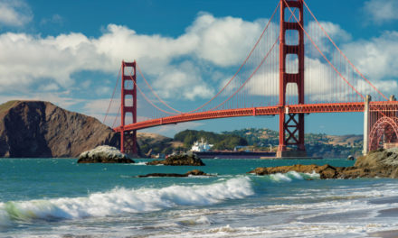
